The Carlsbad Field Office of the Bureau of Land Management uses tDAR to preserve and make available resources created under the Permian Basin Programmatic Agreement.  To date, three projects and 18 additional resources have been added to tDAR as part of this PA.  Contractors perform the work, and upload redacted, public-appropriate resources to tDAR on behalf of the BLM.  Read on for a taste of some of the fascinating work at the Merchant Site carried out by Versar, Inc., and visit the Digital Repository of the Bureau of Land Management, Carlsbad Field Office’s collection in tDAR for all of the completed work that is currently available to the public.

The Merchant Site:  A Late Prehistoric Ochoa Phase Settlement in Southeastern New Mexico

By Myles R. Miller, Tim B. Graves, and Robert H. Leslie

The Merchant site (LA 43414) is a Late Prehistoric Period pueblo settlement located in the southeastern corner of New Mexico near the boundary where the basin-and-range region merges with the southern Plains.  The Merchant site is representative of the Ochoa phase, a poorly understood time period of southeastern New Mexico dating from around a.d. 1300/1350 to 1450.  The Ochoa phase, and the El Paso and Late Glencoe phases of the closely related Jornada Mogollon region to the west, are contemporaneous with the Pueblo IV period of the greater Southwest, the Antelope Creek phase of the southern Plains, and the Toyah phase of central Texas.  As such, Merchant and other Ochoa phase settlements were part of the widespread patterns of population aggregation, migrations, and diasporas and accompanying developments in social and ritual organization that occurred throughout the Southwest, northern Mexico, and southern Plains during the fourteenth and fifteenth centuries.

The Merchant site was first excavated by the Lea County Archaeological Society (LCAS) between 1959 and 1965, but the results of the excavations were never fully reported.  The excavated units and features were never backfilled. In order to remedy this situation, the Carlsbad Field Office of the Bureau of Land Management contracted Versar, Inc. to perform remedial mitigation and investigation of the Merchant site under the Permian Basin Programmatic Agreement.   The 2015 fieldwork included a high-resolution Transect Recording Unit survey, surface mapping and collections, remote sensing, hand and mechanical excavations, and geomorphic studies.  The entire site of LA 43414 was surveyed and mapped, identifying several areas of prehistoric occupations including possible agricultural fields.  The primary focus of the fieldwork was the village area excavated by the LCAS and the possible agricultural fields located 100 meters to the north.

The primary occupation of the Merchant site consists of a group of domestic rooms with stone foundation walls, two deep pit structures, and extensive trash middens.  Excavations in two large and deep pit structures excavated by the LCAS in 1959 and 1960 determined that they served as civic-ceremonial structures.  One of the potentially most significant findings was the discovery of possible agricultural gridded fields to the north of the village area.  Geomorphological, archaeological, and botanical studies were conducted in two possible agricultural features but the results are equivocal.  If future investigations confirm the presence of such features, they will represent the easternmost expression of Southwestern intensive farming practices.

The most significant finding of the reinvestigation of the site is that the architecture and material culture of the Merchant site and other Ochoa phase settlements represents a mixture or hybrid or something entirely new of Southwest and Plains traditions. The collective observations on architecture and material culture establish that the inhabitants of the Merchant site—whether involving one or several resident groups—forged new social identities and perhaps even some manner of hybrid material culture on the southern Plains of the 1300s and early 1400s.  The creation of the unique Ochoa Indented Corrugated ware among the Ochoa phase people of southeastern New Mexico is a visible and prominent identifier of the new social identity of the Ochoa phase migrant communities.  The manner in which the Plains hunters and pueblo agriculturalists interacted—whether symbiotically through exchange, by merging and creating new expressions of ethnicity and identity, or through conflict and warfare—is an important and fascinating topic of investigation for Southwestern and Plains prehistory and broader anthropological theory. The Merchant site and other Ochoa phase settlements of southeastern New Mexico have much to offer for such pursuits.
Guest post by Katherine Spielmann, Professor Emeritus, Arizona State University School of Evolution and Social Change 

When I decided to retire I was faced with making seven seasons of Southwestern excavation data and many, many years of analytical data available to our profession. I spent much of Fall 2015 making that happen through uploading multitudes of excel spreadsheets, associated coding keys, and reports to tDAR. I find tDAR’s functionality in being able to link coding keys to multiple datasets across projects, the ability to integrate my faunal datasets together across projects, and the possibility of future dataset integrations particularly helpful. But there are challenges that I, and perhaps many of us who began our careers relying on paper coding keys need to face while we still have memory and some marbles left. My coding keys for artifact types like lithics, ground stone, fauna, and ceramics evolved over the course of my projects and some of that evolution is documented only on the paper coding keys themselves. Was this ideal? No. A good idea? No. is it reality? Yes. Being the one who worked to upload datasets and coding keys made it possible for me to reconcile the evolving coding schemes and create the appropriately updated digital coding keys where needed. I also grappled with reconciling the multiple datasets on individual artifact types that developed from my first project in the mid-1980s at Gran Quivira when I and the profession in general were just getting a handle on database creation and management. Luckily my students and I had undertaken some of that task years before, but in one case, the black-on-white ceramics, there are two databases that cannot be reconciled (both will go into tDAR with accompanying explanation), and a review of the original collections will be required. If the Western Archeological and Conservation Center makes them available, that would be useful to do.

So my point is to start now on making your past and present part of archaeology’s future while you still have the files and resources at hand and given the ready availability of digital archaeological repositories like tDAR. Working in the Rio Grande area of central New Mexico I’ve always regretted the lack of access to all the information that Edgar Hewett and his henchpeople pulled out of PIV Pueblo sites across the region, and what Nels Nelson found in the Galisteo Basin. They were of the early 20th century. In the early 21st century no discipline can thrive if masses of its data effectively disappear with the passing of each generation.


We’re excited to be travelling to Lincoln, Nebraska later this week for the 74th Annual Plains Anthropological Conference.  We hope that you will stop by our booth in the exhibit hall to speak with a digital curation expert about your digital archaeological information, to enter our drawing for a chance to win a digital preservation package, or just to grab some tDAR swag and say hi!  You can also see our poster “Curating and Preserving Digital Archaeological Data: A Guide to Good Practice” in Salon B/C between 2-4PM on Thursday, October 13th.  If you are in the Lincoln area and want to learn more about tDAR, but won’t be attending the conference, please send an email to laellison@digitalantiquity.org to set up a time to meet.  See you soon!

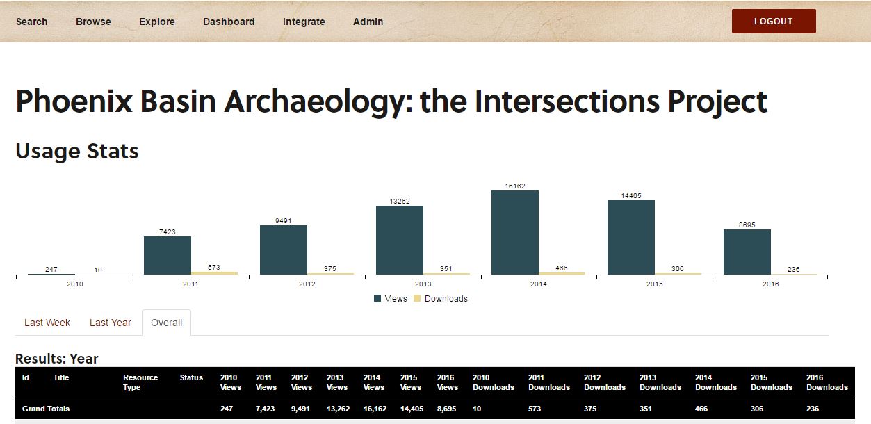
Did you know that if you have digital resources in tDAR you can find out how many people have viewed or downloaded your files?

Here’s how to see your usage stats:

  1. Log in to tdar
  2. Navigate to a resource of yours that you would like to see stats for (you can view an individual resource as well as a collection or project).
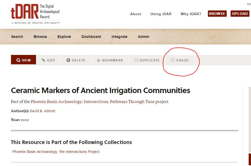
  3. Click on “usage” on the secondary menu bar.usage-tab
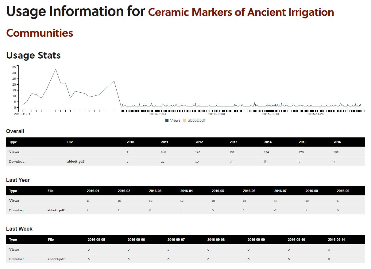
  4. For individual resources you will see a line graph displaying views and downloads for the resource’s history. Views and downloads will also be broken down by year.resource-usage
  5. For collections, usage stats show information for views and downloads by year for the entire group of resources as well as for individual resources in the collection.


collection-usage

Sometimes you might add a file to tDAR and discover later that you need to replace it.  Maybe you found a better scanned version of the document, or maybe you added new data to a data set.  In any case, replacing a file in tDAR is easy, and as long as your new file doesn’t exceed file size range of the previous file there is no charge[1].

First, you will need to log in to tDAR and navigate to your resource.  Select “edit” from the secondary menu bar at the top of the page, and scroll down to the section underneath the heading “attach document files.”    You will see the current filename, and an orange button to the right of it that says “replace.”  You will be prompted to select the file.  Don’t forget to push the blue save button at the bottom or top of the metadata page.  Your new file has replaced your old file!  As a record owner you will also be able to see the history of changes to your file under file information on bottom of the resource metadata page.


[1] Remember that tDAR files are sold in 10MB increments, so if your original file is 3.3MB and your new file is 9.2MB there will be no charge.  However, if your original file is 3.3MB and your new file is 11.6MB you’ll need to pay for an additional file.

Even though the weather is still sizzling and it feels like summer will never end, school is back in session here at ASU this week.  It seems like a great time to remind you that tDAR is a fantastic resource for teachers and students alike.  Educators at all levels can search tDAR for photographs and maps to enhance lectures.  We have hundreds of real data sets that can be used in classroom exercises.  There are even some sample assignments (another) in tDAR, and we would love to see more.  Are you an educator who has made use of tDAR in your classroom presentations or assignments?  Please tell us about it in the comments below!

For your enjoyment, see what we turned up when searching tDAR for these back-to-school themed topics: teaching, schoolhouse, pencil, teacher, notebookapple.

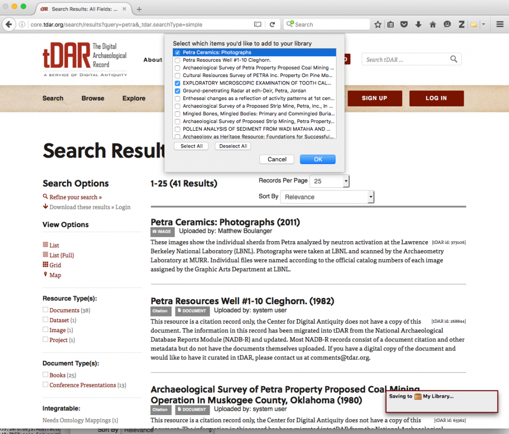
A search in tDAR is likely to reveal a large number of resources that you plan to explore as part of your research.  Did you know you can download your search results as an Excel file?  It is easy!  After you have performed your search, simply click on the “Download these results -> to Excel” link on the left-hand column of the page[1].  Your search results will begin to download immediately.  Use this to create a bibliography or update your bibliographic software (e.g. Endnote).  If you use Zotero to manage your research sources you can easily use the browser-integrated save to select citations from your search results to save in your Zotero library.

Import via Zotero

[1] You must be logged in to tDAR to download your search results

This post was written by guest author Kyle Bocinsky.

A database of 32,863 tree-ring dates from across the southwestern United States—the largest and most comprehensive of its kind to date—is now available through tDAR. To build the database, we started with a smaller database gathered by Mike Berry and the Dominguez Anthropological Research Group and added several thousand dates from archaeological projects across the Southwest. All dates were determined by the Laboratory of Tree-Ring Research (LTRR) at the University of Arizona. We also used the state site databases for the Four Corners states—Compass (Colorado), NMCRIS/ARMS (New Mexico), Utah Division of State History, and AZSITE (Arizona)—to assign site locations (UTMs) to each tree-ring date.

In an associated research publication—Exploration and exploitation in the macrohistory of the pre-Hispanic Pueblo Southwest (Bocinsky et al. 2016)—my colleagues Tim Kohler, Keith Kintigh, Johnathan Rush, and I analyzed these data for macroscalar patterns, and noted a four-peaked pattern in the number of tree-ring dates through time first established by Mike Berry in the 1980s. These four peaks correspond closely to the widely recognized Pecos classification of Ancestral Pueblo cultural phases. We then compared the tree-ring date distribution to a high-resolution reconstruction of the direct-precipitation maize farming niche across the Southwest from AD 500–1400. We argue that each of the Pecos periods initially incorporates an “exploration” phase, followed by a phase of “exploitation” of niches that are simultaneously ecological, cultural, and organizational. Exploitation phases characterized by demographic expansion and aggregation ended with climatically driven downturns in agricultural favorability, undermining important bases for social consensus. Exploration phases were times of socio-ecological niche discovery and development.

In the research paper, we only use the tree-ring dates from AD 500–1400 (29,311 dates), but we include the comprehensive database in tDAR. We’ve posted two versions of the database: one without site locations that is available to any registered tDAR user, and another available only to those who request permission from Tim Kohler or myself. The database contains site numbers and site names, lab (LTRR) numbers, references where available, the outer date (AD), the outer symbol, and the confidence level. To obtain access to the confidential version with site locations, you must demonstrate that you have permission from the managers of the statewide site files in the four states: Compass (Colorado), NMCRIS/ARMS (New Mexico), Utah Division of State History, and AZSITE (Arizona).

We hope that people find this database useful, and we intend for it to be expanded in the future!


REFERENCES

Bocinsky, R. Kyle, Johnathan Rush, Keith W. Kintigh, Timothy A. Kohler, Exploration and exploitation in the macrohistory of the pre-Hispanic Pueblo Southwest, Science Advances 2, e1501532 (2016).

Berry, Michael S., Time, Space, and Transition in Anasazi Prehistory (University of Utah Press, Salt Lake City, Utah, 1982).


There are a few funding opportunities with deadlines this spring that we’d like to share with you.

Cultural Resource Fund Phase II Grants, Due February 15th

The Federal Communications Commission and seven Class I freight rail have created the Cultural Resource Fund to support Tribal and State cultural and historic preservation projects.  You must be among the eligible tribes or States to apply (see here for eligibility).   Fifty competitive grants of up to $50,000 are available during the Phase II funding cycle.  Phase III funding will be announced later this spring.

Council on Library and Information Resources Digitizing Hidden Special Collections and Archives, Initial Proposals Due April 4th

CLIR Hidden Collections grants are designed to fund programs that digitize and provide access to non-digital collections of rare or unique content in cultural heritage institutions.  Funding for projects ranges from $50,000-$500,000 (and the maximum depends on whether you apply as a single institution or as part of a collaborative project).

The National Historical Publications and Records Commission Access to Historical Records, Draft Due April 4th  

The National Historical Publications and Records Commission of the National Archives seeks proposals that promote the preservation and use of historical records collections to broaden understanding of our democracy, history, and culture. This grant program is designed to support archival repositories in preserving and processing primary source materials. The program emphasizes the creation of online tools that facilitate the public discovery of historical records.  Grant funding is available for up to 14 projects of up to $200,000.

If you or your organization is interested in partnering with Digital Antiquity or including tDAR in your proposal please get in touch with us.  We are available to assist with budget development and are interested in potential collaborative projects related to digital preservation of archaeological information.  Please contact us at info@digitalantiquity.org to discuss your project today!

We recently made a change to the way we share new resources in tDAR.  In the past, our Twitter account announced each new resource as it was made live.  Moving forward, we’ll do a weekly round-up and let you know what new resources were added to tDAR during the previous week, with a link to a collection in tDAR where the enthusiastic user can see them all!  Our weekly post will attempt to highlight the breadth of new materials by featuring a few of the newest resources.  

This week’s post will play catch up and cover all the resources made active in tDAR over the last month. There is a wonderful variety represented in this group!  For example, there is a new set of photographs of Norse artifacts from Skútustaðir, including several pipe stem fragments and a die.  The Mimbres Pottery Images Digital Database also added more images last month, such as this Style III bowl.  The Eastern Faunal Working Group made available several new coding sheets and ontologies from the Modoc Rock Shelter Site 1980 excavations as part of their efforts to bring together regional faunal data for synthetic analysis.  Coding sheets and ontologies are used alongside data sets to synthesize raw data using tDAR’s data integration tool. There are also a few new resources from Quantico Marine Corps Base.  If you are interested in the history and use of the base you might find this resource a worthwhile read.  Finally, a paper and data related to gender equity in archaeology are now available!  

To see all the resources made active in tDAR for the period 11/02 to 12/11 click here.